
Monday, December 31, 2012
Saturday, December 29, 2012
Cold tonight with lows into the mid 20s. Occasional snow flurries are still possible this evening and overnight, especially in the higher elevations. Minor accumulations of an inch or less are expected in the lowlands with an additional couple of inches of snow in the mountains. Lingering snow flurries still hang out in the mountains into late Sunday morning. Then high pressure will provide mainly clear skies for Sunday afternoon and evening. But temperatures will stay below freezing with highs only cresting in the low 30s. Next weather system threatens the forecast area with more mixed precip on Monday night/Tuesday.
Friday, December 28, 2012

Not a bad day today. Mainly cloudy with some patches of blue sky this afternoon. Temps are still on the cool side with highs in the mid 30s. Next weather disturbance will lift north into the area to bring rain changing to snow tonight into Saturday morning. Precip will change back to a wintry mix during the day on Saturday, ending as snow on Sunday morning. Here's a look at the snowfall forecast into Sunday morning. 1-3 inches in the lowlands. 3-6" higher up. There's also a winter weather advisory for a large portion of the Mountain State @ 1 AM Saturday. Will post more later today.
Thursday, December 20, 2012


Blizzard warnings, winter storm watches, winter weather advisories, high wind watches and warnings are effective for various times across the Mountain State and surrounding areas. Will break down all the important details this evening. Be prepared for powerful wind gusts along with blowing snow, reduced visibility and possible power outages tonight through much of Saturday... More this evening!
Wednesday, December 19, 2012


Tuesday, December 18, 2012

Foggy in spots this morning. Otherwise today will be cloudy with rain showers diminishing by early afternoon. Highs will stay in the mid/upper 40s. Winds will be in the breezy side this afternoon. A few mountain snowflakes are possible this evening & overnight with lows in the low/mid 30s. Sunshine with a few passing clouds Wednesday. Highs reach the upper 40s. Rainy and mild to start on Thursday. Then that cold front will bring strong winds and light snow accumulations Thursday night into Friday. Cold air sticks around into Christmas.
Monday, December 17, 2012

Sunday, December 16, 2012

Saturday, December 15, 2012

Keep up with that latest radar with this link! http://weather.unisys.com/radar/rad_us_loop.gif
Wednesday, December 12, 2012

ith 50° Thursday & Friday. Sun/cloud mix with low 50s Saturday. Next front will bring chance for rain & a mountain snowflake Saturday night into Sunday. Stronger front brings more mixed precip Tuesday next week.
Tuesday, December 11, 2012

Well we're nearly finished with the marathon of rain that's been goin on here since Friday! Radar is clear for once. But be advised: some drizzle or freezing drizzle may create slick spots this morning. Lingering light snow flurries will also gradually end today. We're left with chilly but calm conditions under a mainly sky through the rest of the work week. Temps stay in the upper 30s/low 40s today. It'll be a chilly night with lows in the 20s. In fact, we have a couple of chilly night in tap this week. Daytime temps will gradually warm into the upper 40s & 50s toward the second half of the week.
Sunday, December 9, 2012

This cold front will bring more rain, gusty winds, thunder and mountain snow by Tuesday! Repeated downpours tonight & tomorrow could cause minor flooding along small creeks and streams by this time Monday. A thunderstorm is also possible Monday afternoon. Weather conditions will become quite breezy and cold as the front passes. On the map you can see at least a 20° temperature drop in a matter of hours Monday night. An inch of snow is possible in the high country by Tuesday AM! Chilly Tuesday with highs in the low 40s & lows in the 20s by Tuesday night.

Lunch time radar check! More rain lifting norteastward to bring another round of early afternoon rain showers. Mild today & tonight. Highs range from the low 60s in the western counties to upper 40s im the eastern panhandle. Morgantown will see a high of 57°. Temps tonight will stay in the low 50s/upper 40s. We'll keep rain in the forecast Monday with highs in the 60s. Much colder with a snowflake or two through the rest of the week.
Friday, December 7, 2012

It'll be a soggy weekend with periods of rain now through Monday. Temperatures remain fairly mild with highs in the upper 50s/low 60s. Lows will hang in the low 40s. Cold front will cross Monday night to bring a changeover to snow flurries just in time for the moisture feed to get cut off. Not expecting a whole lot of accumulation. Again that's not till Monday night/Tuesday. Have a great Friday!
Thursday, December 6, 2012

Image courtesy of HPC is of our 5-day rainfall totals through Monday night. Nearly 2" of rain are possible along the Ohio River Valley. 3/4 to 1 " are likely out east through this weekend.
Wednesday, December 5, 2012

Clearing sky from west to east today. Temperatures will be much cooler than yesterday. Today's high in Morgantown will be 45°. Thats nearly 25° cooler than yesterday but closer to average. Little bit warmer in the east. Cold tonight, low, 25°. Temperatures slowly rebound to above normal for the 2nd half of the week. But we'll keep chance rain showers through the weekend, into early next week.
Picture courtesy of NWS.
Sunday, December 2, 2012

Friday, November 30, 2012
Tuesday, November 27, 2012

Monday, November 26, 2012
We spend much of today under sunny skies with highs reaching into the mid 40s. Increasing late day clouds will bring showers into the Charleston area & western counties by 7 or 8 o'clock. A changeover to snow is expected before midnight as moisture spreads eastward into our state. Minor accumulations generally reaching 2 to 3 inches area expected across much of the area with maximum snowfall amounts in the eastern mountains. Lows will be in the upper 20s/low 30s tonight. Gradual clearing is expected from west to east by midday Tuesday. High pressure will keep mainly sunny skies in the forecast Tuesday afternoon through Friday with temperatures gradually getting warmer each afternoon. We'll finish out the week with highs in the mid 50s!
Sunday, November 25, 2012

Here's the breakdown: With the exception of our higher elevations above 3000 feet (where precip will be ALL snow), much of the forecast area will see rain showers Monday evening. But as temperatures fall below freezing around midnight-1 AM Tuesday, rain will changeover to snow across the lowlands of West Virginia. We could see a few click spots as we head out the door Tuesday morning with an inch or so accumulation. But widespread snow accumulation is not expected. Snow flurries will eventually give way to a rain/snow mix or just rain during the day on Tuesday. Any snow that didn't immediately melt will likely be gone by Tuesday afternoon. In the higher terrain, look for minor accumulations or 2 or 3 inches. Linger mountain snow flurries are likely into early Wednesday. Elsewhere, conditions will be dry but chilly for Tuesday night and Wednesday.
We'll finish out the work week with mainly clear skies with daytime highs reaching into the upper 40s/low 50s. Next opportunity for rain comes Friday night/Saturday as a quick weather disturbance brushes northern West Virginia.
Saturday, November 24, 2012
We'll stay cool today with afternoon highs struggling to get out of the 30s. Lingering snow flurries may amount to an inch or so accumulation in the eastern mountains. Gradually clearing skies & chilly tonight with lows in,the low 20s. Sunshine Sunday with highs in the mid to upper 40s. Rain/snow mix on tap for Tuesday next week. Have a nice weekend!
Friday, November 23, 2012

Monday, November 19, 2012

Sunday, November 18, 2012

Monday, November 12, 2012

High pressure will build into the region behind the front Tuesday, keeping a dry & tranquil forecast through the rest of this week. Highs will top out in the upper 40s to low 50s each day under partly cloudy skies. Lows will sink into the upper 20s/low 30s at night. We'll be watching brief slug of southern moisture trying to lift north & skirt our area later in the week. But it remains unimpressive at the moment. Will tell ya about any changes.
Wednesday, November 7, 2012

Wednesday, October 31, 2012

When will we see the sun again? Sunshine will be on the increase from south to north on Friday. But a quick slug of moisture will bring snow flurries to the mountains and light rain across our lowlands early Friday...THEN we'll clear out in time for the weekend. You'll know you've earned it Saturday when highs reach the mid 50s under mainly sunny skies. Enjoy it. Rain returns Sunday.
Tuesday, October 30, 2012
Lows fall into the low/mid 30s overnight with some slick spots on some roadways. Still feeling the effects of Sandy as the leftovers simmer & depart Wed night/ Thursday. Snow won't be letting up in the high country tonight. Blizzard warnings still in place. Look for an additional 8-10" there & continue to watch for falling trees & branches. Towards the lowlands we'll pick up some minor accumulations of an inch or two by Wednesday morning. Scattered rain showers & mostly cloudy skies on tap for us Wednesday. Snow machine will finally shut down in the mountains Friday.
Temperatures through the rest of the week will gradually warm into the mid 40s. Mainly sunny with highs in the 50 Saturday! Lookin' at rain again Sunday.

We're not out of the woods yet people. Although conditions in Morgantown & most of our lowlands will gradually improve later today as rain mixes with/changes to snow. The rest of the state will continue to pick up steady snow today & tonight. Here is the precip gorecast through the next 48 hours. Above 3000 ft, where snow will continue to fall you can expect another 6-12 inches of snow. Remember that as a general rule, for every inch of rain it's 10 inches of snow...sometimes more! 20% of our state is without power at this time. So if you can, just hunker down & utilize your emergency supplies that you gathered pre-storm and wait this out for the next day or so. If you must venture out, do so with caution. Lots of trees are down. I expect more trees & possibly power lines to come down as more snow piles up! Stay safe & warm!
Good morning friends! Snow in the lowlands of WV will gradually melt as the day wears on. But I'm hearing the pop and crackle of tree branches outside, so be careful if you decide to head out this morning. High wind warnings have expired across Mon county. Still expecting scattered rain showers later today, tonight & Wednesday. In the higher elevations, things are messier. Lots of snow, downed trees and power lines, lots of power outages. Stay safe & warm friends! Gradual sunshine by Thursday!
Sunday, October 28, 2012

2000 feet) we can expect 1-6 inches of heavy wet snow. While above 3000 feet, 1-2 feet are possible! This is in addition to heavy rains & strong winds to 50-60 MPH along the ridge tops! Folks in the mountains will likely see a changeover from rain to snow sometime Sunday night into Monday morning. Again, fallen trees/branches and down power lines are a strong possibility over the coming days.
Friday, October 26, 2012

Back home, we'll cool things off with scattered showers as that cold front passes Saturday into Sunday. Weekend temps will range in the 40s & 50s. But as Sandy progs up the Atlantic coast we'll see lots of moisture AND cold air wrapping around, hitting us from the north/northwest. Overall, we can expect 3-5" of total PRECIP, which could become heavy at times by Tuesday. Some of that precip will fall as wet snow, especially in the higher elevations above 2500 feet. NWS has issued a Winter Storm Watch for Pocahontas, Randolph and Webster counties for late Sunday night through Tuesday evening. Snowfall totals higher up will tally 10-14+ inches! Winds will likely be practically sustained at 25-30 MPH at times with gusts easily twice that early next week.
Across the lowlands, we've got that Indian Summer on our side so the ground melt much of the snow. But trees and power lines will likely accumulate a whole bunch of wet snow. Plus, the winds...If I remember correctly that doesn't end well for the trees or the power lines. Let me just say 'Sandy ain't gonna do us any favors!' We'll have a couple cool days & chilly nights lined up after the clouds break. It would be nice to have some extra firewood/couches laying around to burn in the event of a power outage next week! So go out an extra pack of hot dogs and a case (or two) of beer and let's wait this one out! More tomorrow!

We'll squeeze out one last day of warm weather today with a high of 76°. Watch for morning sunshine then increasing afternoon clouds ahead of that cold front timed for Saturday. Scattered rain showers are likely after dark tonight. Lows fall to near 50°. Saturday we'll open the trap door & temperatures will fall into the 40s & 50s while some breezy winds mix down to the surface. This makes for a chilly, wet weekend. But we're just getting started! By Monday morning temps will have turned cold enough for a changeover to...SNOW. Although much of this wet snow is not expected to stick at first, we could be looking at SEVERAL inches of snow in our mountain counties by Tuesday. Some of the forecast models spit out 12-18" of snowfall in our highest elevations by Tuesday.
Thursday, October 25, 2012

As problematic as hurricane force winds and storm surge are, the rainfall associated with Sandy will be even more troubling for the eastern US...NOT just coastal-but inland flooding and power outages from downed trees and power lines are expected as Sandy hugs the eastern seaboard Sunday into next week. Here is the 5-day rainfall forecast. *Note, Sandy will affect the e'rn US all through next week. This graphic only shows thru Tuesday. Plan now and pass on this info to friends and family!
Wednesday, October 24, 2012
It's another tranquil night across the Mountain State with lows into the low 50s. Thursday looks good with highs reaching the low 80s in the afternoon! We'll see increasing clouds Friday ahead of the next cold front. Weekend weather will turn chilly & wet as the front swings through. We'll also see some moisture leftover from Tropical Storm Sandy, which could bring problematic precip to the eastern US. Will post more on that this evening...Don't forget to go play outside & enjoy the indian summer before it's gone!
Monday, October 22, 2012

We have a nice week of weather lined up across the Mountain State as the blazing Fall colors begin to fade. Lots of warm air will be lifting north into the eastern US ahead of a cold front, bringing daytime temperatures well above normal for much of the week. A weak disturbance will skirt our northern counties with light rain showers Tuesday into Wednesday. Otherwise high pressure will keep the forecast dry & sunny with a few passing clouds. Those afternoon highs will ease into the upper 70s/low 80s through at least Friday. But that cold front will bring rain & cooler temps with highs in the 50s & 60s by the weekend.
Friday, October 19, 2012

Friday night forecast looks partly cloudy with isolated light rain showers & lows dipping into the mid 40s. Saturday will be cool with highs only reaching the mid 50s under partly to mostly cloudy skies. An afternoon rain shower or two are possible, especially across our northern counties. But skies will clear in time for the 7 PM kickoff against KS State. We'll be left with near perfect October football weather! Sunday looks partly cloudy with highs near 60. Warmer next week...
Thursday, October 18, 2012

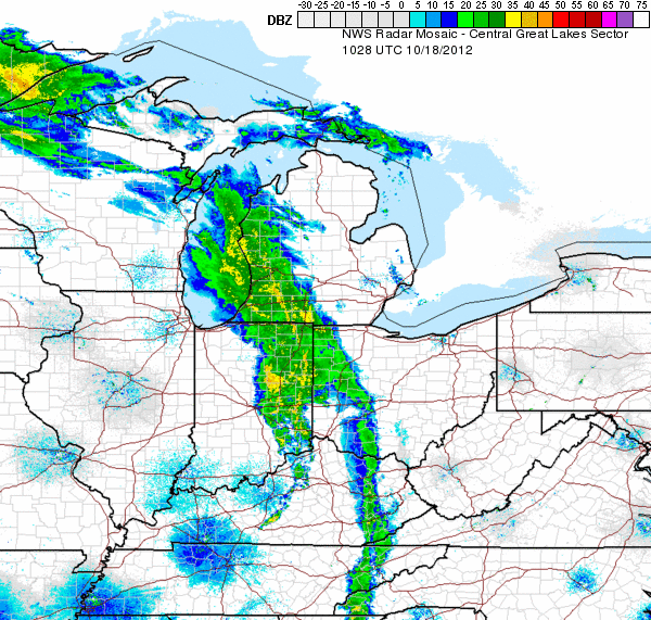
Another warm day is on tap with highs in the upper 60s. But here comes the cold front! We've seen some heavy rain & strong winds as this system pushes eastward across the Ohio Valley. Some weakening is expected this morning as it encounters the mountains of West Virginia. Then by lunchtime we can expect some restrengthening into this afternoon. Gusts will approach 20-30 mph at times, especially across our Potomac Highlands & the Eastern Panhandle. The Storm Prediction Center has included all points east of I-79 in their slight risk of severe weather for this afternoon & evening. Leftover rain showers will slowly wind down early Friday. Then a chilly wet weekend is in store in our northern counties.
Wednesday, October 17, 2012

Winds ahead of this cold front will be out of the south today, bringing temperatures into the upper 60s/70s this afternoon. Increasing clouds tonight with temps hanging near 50. Breezy & rainy Thursday as the front slides eastward. Cool with leftover showers in our northern counties into Friday. Temperatures will remain on the cool side with highs in the 50s & low 60s as we kick off the weekend.
Saturday, October 13, 2012

Our Sunday forecast doesn't look too bad. Highs will reach into the upper 70s to 80°! We'll see mostly cloudy skies and some strong winds gusting to 20 MPH at times. Scattered rain showers are likely. But any thunderstorms are expected to weaken pretty quickly as they drift eastward into WV. So the winds, warmer temps and a little rain will be the main weather impacts tomorrow. Next week is shaping up nicely so far...

Here's the latest satellite image. We're sunny today with temps in the 70s. Leading edge of those clouds will prog eastward this evening, bringing breezy conditions along with rain & a rumble of thunder by Sunday. Temps will stay mild overnight with lows in the 50s. Will post more about Sunday's weather in a bit! Have a great weekend & s'go MTNEERS!!
Friday, October 12, 2012

Cold front drapes cloudy skies across northern WV today. Not much moisture aloft means we'll likely stay dry as the front moves through. Afternoon temps creep into the low 60s. Then another chilly night is in store under clear skies. Lows will teeter around freezing for much of the mtn state. Saturday still looks dry & warmer with plenty of sunshine during the day. Southerly flow will bring warmer air with highs into the 70s. Watching the next system to bring gusty winds Saturday night followed by rain & thunder Sunday.
Wednesday, October 10, 2012

A revision for you: NWS has upgraded/expanded our warning for tonight. Now, nearly all of WV will be under a freeze warning (bright blue) until Thursday morning as lows fall into the 20s & 30s. At this point it's easier to tell ya which counties are NOT under a freeze warning. Basically the easternmost counties of the eastern panhandle of WV are excluded from this warning. So that's Hampshire, Hardy, eastern Mineral, Jefferson, etc. Nonetheless, it will be chilly. I recommend pants!

Here is the latest from the NWS. Navy blue=freeze watch, light blue=freeze warning from tonight through early Thursday. We'll keep it breezy today as that cold front pushes eastward across the Mid Atlantic states today & tonight. Sky will clear up overnight, allowing for a very chilly night. Dry & mild Thursday with highs near 60. Light rain returns Friday. We'll squeeze out another nice weekend with highs in the 70s!

Light rain showers will skirt mainly our northern counties today. Highs reach into the low 60s. Clear & chilly tonight with temps dipping into the upper 20s/low 30s. Frost advisories, freeze watches & warnings are in effect across much of the Mountain State. Will post more on that in a bit. Gradually warmer in time for the weekend! Have a great day!
Friday, October 5, 2012
Happy Friday! Mainly sunny today with increasing late-day clouds & a high of 77°. Scattered showers will spread eastward into the Ohio Valley & across WV tonight, carrying over into Saturday. Temps drop into the low/mid 50s overnight. Morning rain Saturday with gradual drying in the afternoon. Temps will stay in the 50s Saturday. Saturday night will be mainly clear & chilly with lows in the low/mid30s. Sunday will feature another round of morning rain showers with highs in the low/mid 50s. Overnight low on Sunday will teeter on freezing. Frost and a snowflake or two are likely in our mountain counties.
Thursday, October 4, 2012

Tuesday, October 2, 2012

Clockwise from top left, tornado probability, damaging wind probability, latest radar, latest satellite. Periods of rain & gusty winds expected today. Any afternoon/evening storms could become severe with highest chance for severe weather along our western counties. As you can see, tornado development is not out of the question in the afternoon hours. Will need to stay alert for quickly changing weather & be ready to seek shelter indoors in the event of severe weather today!
Monday, October 1, 2012

Sunday, September 30, 2012

We'll stay on the southern periphery of a closed low pressure system over the Great Lakes Sunday. This will toss some cloud cover into West Virginia, keeping things on the cool side. But there's only a slight chance of rain across a couple of our northernmost counties this afternoon. Otherwise, temps will stay in the mid/upper 60s under mainly cloudy skies. Tonight, expect gradually clearing skies on the backside of that departing low pressure with lows falling into the mid 40s. This will set us up for another foggy start Monday morning. Then sunshine is on tap for mid-morning into early afternoon with highs closing in on 70°. But a deep trough currently sweeping across the Mississippi River Valley will lift north, effecting our forecast area Monday evening into Tuesday. This system will have plenty of moisture to work with & we could see some locally heavy downpours with minor water problems possible towards the end of the week.
Another cold front will swing in from Canada to bring a sharp cool dwn & chance of rain late in the forecast (next Sunday).
Another cold front will swing in from Canada to bring a sharp cool dwn & chance of rain late in the forecast (next Sunday).
Friday, September 28, 2012

Drier air will fill in from the north overnight into Saturday. Cool temps linger through the weekend with rain Sunday...Clearing skies will allow for some morning fog as temps fall into the upper 40s overnight. Bring a light jacket for Saturday morning & peel it off as you make your way to the stadium. We'll stay dry & partly cloudy with highs leaning on 70. Next weather disturbance will swing in from the north with rain Sunday. Monday looks dry. Rain possible Tuesday.

Some low level moisture lingering in the southern part of the state continues to provide rain shower activity today. Drier air mixes into our northern counties as we hang ourselves out to dry. High pressure will provide a mainly dry forecast overnight & into Friday. Lows will fall into the upper 40s/low 50s with patchy fog for Saturday morning. Saturday looks mainly sunny with highs in the upper 60s to 70°. Another disturbance will creep up for Sunday. Dry & mild Monday. Rain again Tuesday/Wednesday next week.
Thursday, September 27, 2012

Wednesday, September 26, 2012

Subscribe to:
Posts (Atom)