Wednesday, June 29, 2011

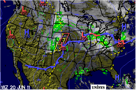
    Thanks to high pressure, we have clear sunny skies as we wave goodbye to June. Other than some patchy valley fog along some of our waterways overnight, skies stay generally clear till more moisture arrives late Friday. Highs today and Thursday will be in the low 80s. Look for lows in the low 50s/upper 40s tonight & Thursday night. Dewpoints have really bottomed out, in the low 50s. We'll keep this somewhat mild forecast with low humidity until July.

    Things will really start to heat up for the holiday weekend. Warm front will approach from the west Friday, providing warmer temps, more humid conditions & chance for showers and a few thunderstorms Friday night into Saturday. Highs will be in the upper 80s Friday, then low to mid 90s Saturday & Sunday. Aside from a brief evening storm, our Saturday weather should hold out.

    I like good news as much as the next guy. But the front will stall over our area Sunday into Monday. We'll keep partly to mostly cloudy skies and scattered showers & storms in the forecast for the 4th of July. Hopefully our holiday forecast will clean up over the next 24-48.

Elsewhere...

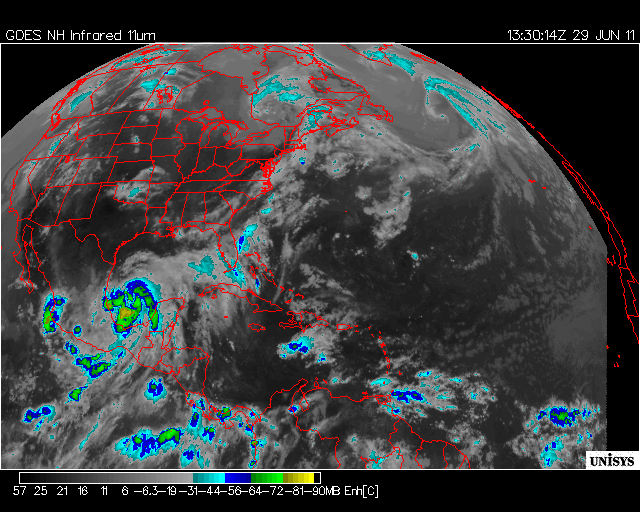
    Tropical Storm Arlene is our first Atlantic storm of the season. With the help of our GOES satellite we can see that she is beginning to show rotation 175 miles east of Tampico, Mexico. She's heading WNW at aprox 7 knots. Estimated minimum pressure is 10.01 millibars. Max sustained winds are at 35 knots with gusts to 45. Forecasters predict winds to increase to 40 knots with gusts to 45 knots in the next 12 hours. However upon making landfall Arelene will weaken considerably. She will bring some much needed rain to northern Mexico & southern Texas.

Tuesday, June 28, 2011

    Cold front crosses the area later today. Most of the shower & storm activity is isolated to the Mississippi River Valley, inside those yellow watch boxes. We spend much of the day dry with highs in the mid 80s under party cloudy skies. A few broken showers and storms may fire along the frontal boundary later this afternoon & evening. We'll continue to see breezy conditions into tonight. But strong high pressure will build into the area tonight, providing clearing skies though the end of June.

     Lows tonight will be in the upper 50s. Scattered fog will develop early Wednesday. Otherwise lots of sunshine is in store Wednesday and Thursday. Dewpoints will be in the low 50s. Temps will range from low 80s during the day to low to mid 50s at night.

    Moisture will begin to creep back into the forecast as a warm front Friday. A few showers & storms are possible as things warm up during the day Friday. A couple of shortwave disturbances will skirt the area Saturday, leaving us open for a few pop up showers and storms Saturday into Sunday. Things will really warm up as we transition from June to July. How do you like highs in the low 90s, lows in the 70s? For now, we'll keep a slight chance of showers and thunder for the holiday.

Monday, June 27, 2011

    Warmer & muggy with rain showers and isolated thunder ahead of a cold front crossing the Lakes today & tonight. Rain Tuesday. Drying out with lots of sunshine for the second half of the work week. We'll keep warmer conditions into the holiday weekend.

    Warm front lifts north today ahead of a cold front crossing the Southern Great Lakes. We have a sun/cloud mix with highs in the low 80s today. There is a slight chance for severe weather to fire off this afternoon/evening, especially along the Ohio River. Elsewhere, we'll see showers and perhaps an isolated storm overspreading into our area this evening into the overnight.

    For tonight, we have a relatively warm, muggy night on tap. Low level clouds and lots of moisture will keep lows in the mid 60s. Rain showers & potential for severe weather continues into Tuesday. Highs will be in the low to mid 80s again. System may weaken upon crossing the Ohio River Valley. Still have to keep possiblity of precip in the forecast until Tuesday evening.

    High pressure will build into our area by Tuesday night. We'll begin to see clearing skies Tuesday night into Wednesday. Lots of sunshine is on tap for midweek. Highs will be in the low to mid 80s Wednesday and Thursday. Warmer air & moisture on deck Friday. Not impressed with our weekend forecast ATTM.

Our convective outlook courtesy of SPC

Friday, June 24, 2011


    Fragmented leftover showers & isolated storms are all but gone today. High pressure and drier air now beginning to build into the area. Things stay mostly cloudy today and overnight. A few mountain showers may occur overnight. Lows will stay in the upper 50s/low 60s with the cloud cover.

    Lots of cooler air will be mixing into the area on a northwest upper air flow. Will see some patchy valley fog & low level clouds tonight into Saturday morning. But plenty of sunshine is on deck tomorrow. So highs will be right around 80. Higher elevations may see a brief raindrop associated with the northwest flow. Elsewhere, weather will be ideal! Saturday night will be coolest in a while. Lows will dip into the low 50s. Should make for nice camping weather down at Wapocoma camping in Romney for the South Branch Bluegrass Festival!

     But plan on packing the tent up early Sunday. Dry forecast is now eroding faster than previsouly expected. Respectable shortwave disturbance will move through the area Sunday afternoon/evening. Main show looks to ramp up showers and a few storms Sunday night & into Monday with frontal passage. System will exit north of our area by Monday night. Leftover showers are possible Tuesday. We'll dry out again by Wednesday.

Thursday, June 23, 2011

    We spend another day under a caution flag with threat for a few storms & breezy conditions mainly late this afternoon and evening.  Storms will still be capable of producing locally heavy rainfall. But latest satellite imagery & supporting model guidance depicts a nice punch of dry air building in behind the frontal boundary, setting the scene for a generally dry & cooler weekend. Rain chances return for Wednesday & Thursday next week.

    For today skies will stay mostly cloudy, highs will be in the low 80s. A bit of a dry slot will reduce our rain chances for much of the day today. Northwest flow & rotation off the Great Lakes low pressure system will toss more moisture, fragmented showers & storms into our area later this afternoon & evening. Lows fall to the low 60 tonight.

    A few leftover showers are on tap for Friday. Otherwise, the front will push east of our area & forecast will begin to settle down in time for the weekend. Highs Friday will be in the mid 70s under partly cloudy skies. A quick shortwave disturbance will skirt the northern zones Saturday. We may see a raindrop and pehaps a pop up thunderstorm or two Saturday. Aside from that small chance of rain Saturday, things will really dry out Sunday into Monday. Highs this weekend will be in the mid to upper 70s!!! Beautiful weather on tap Sunday & Monday. Mercury will touch 90 for the first half of next week. Next rainmaker comes Wednesday & Thursday.

Wednesday, June 22, 2011

    Large low pressure cold front will slowly lumber across the Great Lakes, keeping the threat of severe weather in the forecast through the rest of the work week. Cooler air on the backside will provide some relief from opressive heat in time for the weekend. Things really dry out by Sunday & into next week.

    We'll stay in the warm sector of that cold front over the next few days. Hot and humid conditions persist across much of the eastern US as lots of warm moist air lifts north ahead of the frontal boundary. We'll see a bit more sunshine today than yesterday. Highs will again top out around 90. Scattered thunderstorms will again develop by late afternoon into this evening. Any storms that crop up will be capable of producing heavy rainfall, strong winds and hail. We'll see breezy conditions with gusts into the teens tonight & over the next 48 hours.

    Low pressure cold front will continue its gradual eastward track Thursday...departing Friday. We'll keep the threat for isolated severe weather Thursday. But that threat will be waning as we finish out the work week. A nice punch of dry air will fill into the region Thursday into Friday. Dewpoints will fall back down to the 50s. Cooler temperatures will filter in on the backside of the front late Friday. This will put highs in the upper 70s Friday & into the weekend. Lows will fall into the upper 50s!

    Slight chance for thunder will still linger into Saturday afternoon and evening. Convection will be isolated but like the past few days, pop up storms could produce locally heavy rainfall, breezy conditions and hail. By Sunday, things will really dry out aloft and at the surface. Rain chances diminish to almost nil for at least the first half of next week.

Surface map courtesy of Unysis Weather shows large cold front lumbering across the Lakes

Tuesday, June 21, 2011

     More unsettled weather is on tap today despite the upper level ridging helping to provide somewhat clear skies. Longest day of the year, max sun angles, plenty of daytime heating provide hot and humid weather again today. Highs will be around 90. These factors along with a couple of shortwave upper level disturbances passing our area will trigger a few thunderstorms this evening and tonight. ETA on storms crossing our area is sometime after 5 PM.

     Any storms that do cross the mountains could produce heavy rainfall & flashy water problems like ponding on roadways. Damaging winds and hail are also possible (the latter being somewhat unlikely). Things will stay muggy tonight. Storms continue after dark. Lows fall into the upper 60s under mostly cloudy skies.

     Cold front will slowly cross the Central Plains Wednesday. Highs will be in the mid to upper 80s during the day. We'll keep the threat of showers and thunderstorms in the forecast Wednesday through early Friday. Again, localized water problems may arise through the end of the workweek. Highs Thursday and Friday will be in the lower 80s. Threat for showers and storms will gradually wane by the end of the week. Cooler temperatures and more tranquil weather awaits for this weekend into next week!

     Map depicts our convective outlook courtesy of the SPC

Monday, June 20, 2011

     Our weekend system still delivering light rain in the east will gradually exit stage right. Quick on the heels of that system is another low pressure system crossing the Ohio River Valley & reaching the Appalachians this afternoon. We'll keep the threat for showers and thunderstorms this afternoon into our overnight.

     High precipital water values mean that plently of moisture is available to these storm systems. Any storms that do make it into our area could produce heavy rainfall. With soils still for the most part saturated, heavy rainfall could create flashy water problems like ponding on roadways. Storms may also produce damaging winds and hail into the overnight. We'll stay in the warm sector tonight, keeping a muggy feel to the air. Lows will be in the mid  to upper 60s.

     Tuesday we'll see a few peaks of sunshine as upper level ridging helps to clear out any leftover muck. It'll be summer solstice with max sun angles in the northern hemisphere. We'll also be in the warm sector of a cold front crossing the Midwest. So a generally southwesterly air flow will pull lots of warm humid air into our area. This along with max solar intensity plus longest day of the year means temperatures will be about ten degrees hotter than today. So we have to keep a slim chance for these factors to combine to allow for some late day convective thunderstorms for our area.

     Cold front will cross our area Wednesday & Wednesday night. Again we'll have a chance for heavy rainfall  and scattered thunderstorms. Highs will be in the mid to upper 80s. Lows will still be in the mid to upper 60s. We'll keep isolated thunder through the rest of the work week. Weather will calm down with sligthly cooler temps in time for the weekend.

Friday, June 17, 2011

     Model guidance has demonstrated several discrepancies regarding the handling of a stationary front that will camp out over the Appalachians through Father's Day weekend. This system, along with a steady westerly upper air flow will provide mechanisms for scattered showers and potentially severe thunderstorms each day into early next week. Some questions still exist regarding the timing and track of a series of shortwave disturbances. But we can expect occasional showers and Tstorms with potentially damaging winds and/or hail to develop with peak daytime heating in the afternoon and evening each day through the short term forecast. Any heavy downpours that do occur would create potential water problems, especially where soils are already saturated due to recent rains.

     Dewpoints will for the most part, be in the mid 60s. Air will be nearly saturated and humid condtions will persist. We will also see slightly above average temperatures this weekend. Highs Saturday will be in the mid to upper 80s. Lows will stay in the mid to upper 60s. This may make nights nearly as uncomfortable as our upcoming days!

     Although high pressure will provide the possibility for some relief from the thunder, our area will remain vulnerable to scattered showers and storms through next week. Tuesday marks the summer solstice and the first day of summer. With max sunshine & daytime heating, we will still be susceptible to convective afternoon & evening storms. Highs will reach the low to mid 90s across much of our state to mark the official start of summer. Will report on this as better information becomes available! Meantime, happy father's day!!

Wednesday, June 15, 2011


High pressure and clear skies will give way to clouds, rain showers and thunder by tonight. Latest satellite imagery depicts very moist air mass with a few embedded thunderheads meandering across the southern Great Lakes this morning. We can make out some high level cirrus clouds ahead of the occluded frontal boundary encroaching from the west. Also associated with the front is a warmer air mass riding along an increasingly southwest air flow. This marks a gradual warming trend which will continue well into next week. This is good news for all you kids with blue lips shivering by the pool; bad news for big hairy dogs.

For the rest of today, temps will get into the upper 70s. Expect increasing afternoon & evening clouds. Southern coal fields of West Virginia may see severe weather today/tonight. Elsewhere, breezy conditions, rain showers and isolated thunder are expected tonight but widespread severe weather is not expected to fire off this far east. Lows tonight will fall to around 60. System will exit stage right by Thursday morning.

Thursday, will be mostly cloudy with a few peaks of sunshine. Highs will be in the upper 70s again. Another upper level low pressure system will ride into town late in the day. This along with a few upper level disturbances will keep a chance of occasional rain showers & thunderstorms in the forecast Thursday through Sunday. Temperatures will gradually warm into the upper 80s to start next week.

Tuesday, June 14, 2011

    We have just a few high level clouds today with below normal temperatures topping out in the low to mid 70s. Upper level low pressure trough will graze PA, MD & the north zones of WV. Low level moisture does not look sufficient to enough squeeze out anything more than some drizzle or maybe some virga this afternoon in those northern zones & some of the mountain counties. Virga is rain that does not reach the ground. Otherwise, high pressure over the Great Lakes contributes to somewhat clear and calm weather today and tonight. Lows will again fall into the low 50s, upper 40s and conditions will be calm enough for fog to develop early Wednesday.

    Warm front will push through Wednesday night into Thursday. Ahead of the front we can expect increasing cloudiness & warmer temperatures as a result of a southwesterly air flow. Showers and thunderstorms are expected Wednesday night/Thursday AM. Plenty of available moisture along with that system could produce locally heavy  downpours given the right conditions. Lows will be in the upper 50s, low 60s.

    We'll see a gradual clearing Thursday from southwest to northeast. Low pressure system will exit to the northeast. The passing of this front will mark a more seasonal temperature trend. This will  put daytime highs in the low to mid 80s, then closer to 90 by next week. We'll keep slight chances for rain and thunder Friday and Saturday. Skies will clear out late Saturday. Rain returns late Sunday.

Map shows HPC depiction of predicted 5-day rainfall totals. We'll get our fair share.

Monday, June 13, 2011

    Northerly air flow aloft brings refreshing temperatures today and tomorrow. Rain chances and warmer air is on tap for Wednesday. We'll keep rain in the forecast Thursday & Friday. Low pressure will finally make an exit by early Saturday. ETA on another big warm up is next Wednesday.

    For today, it's a sun/cloud mix early with clearing skies into this afternoon & evening. Upper air flow out of the north allowing lots of cool air to mix in with surface temps. Highs will reach a modest 75. Thick valley fog will develop overnight. Otherwise, skies will be generally clear. Lows fall to around 50 tonight.

    Plenty of sunshine is in the forecast for Tuesday. Temperatures will stay pleasant with highs in the low to mid 70s. Weak low pressure will encroach on the northern sections and the Eastern Panhandle Tuesday evening. So these zones may see a drop of rain Tuesday evening. Low will then push northeast leaving generally clear skies Tuesday night into early Wednesday.

    Stronger low pressure will make its way into the Great Lakes region during the day Wednesday. Expect increasing cloud cover, showers and a few thunderstorms Wednesday afternoon & evening. Warmer temperatures are also in store as the upper air flow turns southwest ahead of the front. We'll be in the warm sector from Wednesday into next week. Clouds, rain and thunder will stay in the forecast Thursday, Friday and early Saturday as that low stalls over the Appalachians. Rain ends Saturday evening. Even warmer temperatures are in store by midweek next week.

Friday, June 10, 2011

     Yet another hot humid day with afternoon popcorn thunderstorms into tonight & Saturday. Skies will offer some sunshine early with highs around 90 again today. Clouds will be on the increase ahead of a cold frontal boundary tracking across the southern Great Lakes early this morning. Radar depicts storm activity with embedded thunder as far south as I-70 in southeastern Ohio. This will bring a round of showers and storms to northernmost portions of West Virginia by mid afternoon.

      Occasional storms will continue to fire across the Mid-Atlantic states this evening and overnight. Storms could produce heavy rain which would create more water concerns along creeks and streams. A flash flood watch for central West Virginia & eastern Ohio from last night was extended into this evening. Humid conditions with fog and haze will stay with us overnight. Lows tonight will fall into the mid 60s.

      We can pretty much copy and paste the same forecast in for Saturday. We'll put up with one more day of hot & humid conditions with highs around 90. Saturday will not be a total loss but more severe weather is on track for Saturday night. Lots of low level moisture & daytime heating will clash with a cold frontal boundary Saturday night. This will bring another round of potentially severe weather & flooding concerns to our area. Slow-moving or stationary storms would further irritate any existing water problems Saturday night. Lows fall to the low to mid 60s. But cooler air awaits!

      High pressure will usher in a real nice punch of dry air for Sunday. A few leftover showers and low level clouds will linger in the mountains Sunday morning...clearing by noon. Otherwise we have sunny dry conditions with dew points falling back down into the low 50s & upper 40s. Highs will be in the upper 70s Sunday, and then in the low 70s Monday! Generally clear and mild conditions prevail next week until POPs increase Wednesday night/Thursday.

Thursday, June 9, 2011

    It's another hot, muggy day today with highs around 90. Skies stay mostly sunny during the day. But daytime heating & lots of moist will combine with a weak frontal boundary to bring rain late day showers and thunderstorms to parts of the Midwest, Ohio Valley and northeast. Convective storms are forecast to become organized and spread south into portions of northern West Virginia this evening. NWS has issued a severe thunderstorm warning to expire at 8 PM for nearly all of West Viriginia, eastern OH and parts of PA. Primary threats to our area will be damaging wind and hail.

    Any storms would bring welcome rain & help displace much of the heat of the day. Showers and isolated thunder is expected to continue into tonight. Lows will fall into the low to mid 60s.

    Frontal boundary will waiver over the Appalachians Friday & gradually lift north later Friday. Skies will stay mostly cloudy with just a few peaks of sunshine during the day. Hot forecast with occasional showers and storms will continue Friday and Saturday. Highs will be in the low 90s both days.

    Cold front will arrive Saturday night with more showers and possible severe weather into early Sunday. Then slightly cooler temperatures and drier air will round out our forecast for Sunday PM & for the first few days of next week.

Wednesday, June 8, 2011

    Another sunny hot forecast today with lots of sunshine. Highs in the mid 90s will likely break a few records across the state today and perhaps Thursday as well. Heat advisories are still in effect for much of the east. But slightly cooler temperatures will make their way into the forecast by the end of the weekend.

    We stay dry through tonight. Lows will be in the mid 60s under mostly clear skies. Some isolated fog and haze will creep into the early hours Thursday. But the forecast will still be sunny and humid for most of the day. Highs will again reach the mid 90s.  A weak frontal boundary will sweep through the region Thursday night. This will bring occaional showers and thunderstorms Thursday night, Friday and into the weekend. Skies will be mostly cloudy from Thursday night through early Sunday.

    Once we get through the record-breaking midweek tempeatures, daytime heating be kept in check for the weekend. Highs will only be in the mid to upper 80s. We'll dry out with average temperatures for Sunday and Monday. Extended forecast is hinting at another rainmaker by Thursday next week.

Tuesday, June 7, 2011

   A vigorous shortwave disturbance tracked south southeast from the Great Lakes this morning. Dry air aloft has done a good job preventing most of the severe weather from firing across northern West Virginia today. Most severe weather has been limited to areas along the Ohio River. Instead we get a healthy dose of rain today. Low level clouds, rain showers and isolated thunder will linger through the afternoon and evening, especially in the northern portions of our state. Highs will be in the mid 80s across much of the state. Temps will trend closer to 90 further south.


    High pressure will begin to take hold tonight into Wednesday. So skies will begin to clear overnight. Lows will be in the mid 60s. Expecting some fog and haze to develop again tonight into Wednesday morning. Otherwise, high pressure will maintain control over the region during the day Wednesday. Forecast will stay sunny, hot and humid with highs in the mid 90s. This may tie or break some records across the state for daytime highs tomorrow.


    High pressure will erode from the north by Thursday. A series of upper level disturbances will bring occasional showers and thunderstorms Thursday through Saturday. Cold frontal boundary and cloud cover will bring slightly cooler temperatures through the weekend. Highs will be in the upper 80s. Lows will stay in the low to mid 60s. Things will dry out for Sunday and Monday.

Monday, June 6, 2011

    We get lots of sunshine again today with highs in the mid 80s. Things really begin to heat up for the rest of the country as lots of warm, dry continental tropical air lifts north. Drought and wildfires are already beginning to make headlines across the south. This trend will continue with little in the way of relief in sight.

    Meanwhile, a weak warm front will lift north into the Ohio Valley tonight. This may squeeze a rain drop or two across the northern zones. Limited moisture aloft will keep rain chances elsewhere at a minimum. Fog and haze will be more widespread tonight and early Tuesday. Lows will be around 60 with upper 50s in some of the valleys overnight.

    Widespread thunderstorms will be firing off during the day on Tuesday. Highs will close in on 90 tomorrow. Plenty of warm air & moisture will be available, making for another busy day for forecasters and storm chasers. A few storms may sag far enough south for some severe weather threats to be warranted for our area Tuesday afternoon.

    Once the initial frontal boundary passes late Tuesday, any leftover rain showers will be fragmented and short-lived. Otherwise things will begin to dry out after sunset. Just a few broken clouds will linger overnight into Wednesday morning. Lows will be in the mid 60s.

    More hot and humid weather is on tap for Wednesday and Thursday. Forecast will stay generally dry with highs in the low 90s with lows in the mid to upper 60s. Plenty of sunshine is still in the forecast for Wednesday into most of Thrusday. But deeper moisture and cold frontal boundary will cross to our north Thursday evening & overnight. This will toss more rain showers and isolated thunderstorms into our area Thursday night and Friday. Hot, humid forecast with rain/thunderstorm chances last into the weekend.

Friday, June 3, 2011

    Forecast for today is mostly sunny with a chance of awesome! Just a few high level cirrus clouds are creeping into the region ahead of a weak approaching cold front today. Otherwise high pressure continues to camp over the Great Lakes & Mid-Atlantic states. Conditions at the surface and aloft will stay very dry with highs around 80. Watch for a pretty sunset tonight with lows falling into the upper 40s.

    We'll see a good deal of sunshine across the area early Saturday. Cold frontal boundary will push through Saturday night/Sunday. Best chance of a raindrop & isolated thunderstorm will be during this time. Expect more humid air to move in during the day with highs in the low to mid 80s. So look for increasing clouds with strenghtening winds as the day progresses. Lows will be in the low 60s.

    On Sunday, any leftover showers will dry out fairly quickly. Cloud deck will erode from west to east, leaving plenty of dry air into next Monday. Hot and humid forecast returns Tuesday. Increasing moisture will allow for a few stray thunderstorms to develop in the afternoon & evening hours Tuesday through Thursday. Otherwise forecast will stay mostly sunny with temperatures topping out in theupper 80s, edging close to 90.