Friday, October 19, 2012

Friday night forecast looks partly cloudy with isolated light rain showers & lows dipping into the mid 40s. Saturday will be cool with highs only reaching the mid 50s under partly to mostly cloudy skies. An afternoon rain shower or two are possible, especially across our northern counties. But skies will clear in time for the 7 PM kickoff against KS State. We'll be left with near perfect October football weather! Sunday looks partly cloudy with highs near 60. Warmer next week...

Thursday, October 18, 2012

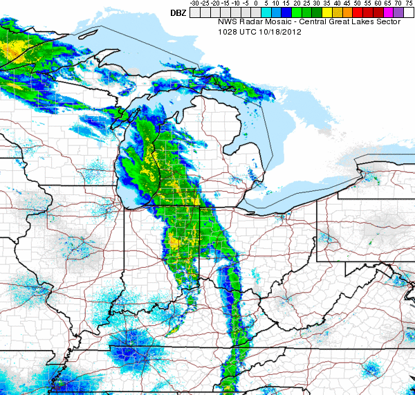
Starting to see some strong wind gusts out ahead of the frontal boundary. Rain showers & a few Tstorms likely later this afternoon & evening, especially in the eastern half of our state.

Another warm day is on tap with highs in the upper 60s. But here comes the cold front! We've seen some heavy rain & strong winds as this system pushes eastward across the Ohio Valley. Some weakening is expected this morning as it encounters the mountains of West Virginia. Then by lunchtime we can expect some restrengthening into this afternoon. Gusts will approach 20-30 mph at times, especially across our Potomac Highlands & the Eastern Panhandle. The Storm Prediction Center has included all points east of I-79 in their slight risk of severe weather for this afternoon & evening. Leftover rain showers will slowly wind down early Friday. Then a chilly wet weekend is in store in our northern counties.

Wednesday, October 17, 2012

Winds ahead of this cold front will be out of the south today, bringing temperatures into the upper 60s/70s this afternoon. Increasing clouds tonight with temps hanging near 50. Breezy & rainy Thursday as the front slides eastward. Cool with leftover showers in our northern counties into Friday. Temperatures will remain on the cool side with highs in the 50s & low 60s as we kick off the weekend.

Saturday, October 13, 2012

Our Sunday forecast doesn't look too bad. Highs will reach into the upper 70s to 80°! We'll see mostly cloudy skies and some strong winds gusting to 20 MPH at times. Scattered rain showers are likely. But any thunderstorms are expected to weaken pretty quickly as they drift eastward into WV. So the winds, warmer temps and a little rain will be the main weather impacts tomorrow. Next week is shaping up nicely so far...

Here's the latest satellite image. We're sunny today with temps in the 70s. Leading edge of those clouds will prog eastward this evening, bringing breezy conditions along with rain & a rumble of thunder by Sunday. Temps will stay mild overnight with lows in the 50s. Will post more about Sunday's weather in a bit! Have a great weekend & s'go MTNEERS!!

Friday, October 12, 2012

Cold front drapes cloudy skies across northern WV today. Not much moisture aloft means we'll likely stay dry as the front moves through. Afternoon temps creep into the low 60s. Then another chilly night is in store under clear skies. Lows will teeter around freezing for much of the mtn state. Saturday still looks dry & warmer with plenty of sunshine during the day. Southerly flow will bring warmer air with highs into the 70s. Watching the next system to bring gusty winds Saturday night followed by rain & thunder Sunday.